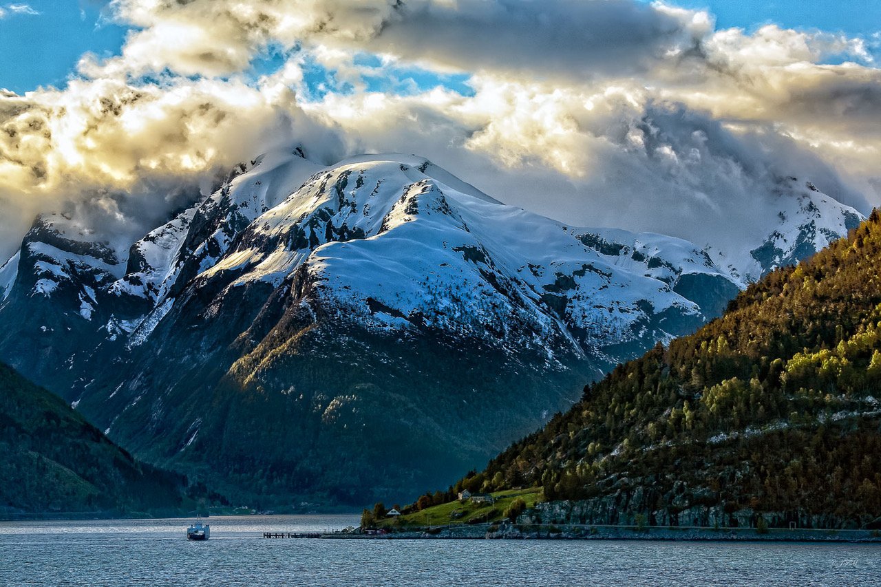
Sognefjord Ferry
This is the NORLED ferry company people ferry (no cars) making the trip through the Sognefjord. The Sognefjord or Sognefjorden, nicknamed the King of the Fjords, is on the UNESCO World Heritage List in 2005. It is the largest and deepest fjord in Norway. Located in Vestland county in Western Norway, it stretches 205 kilometers (127 mi) inland and plunging up to 1,308 m (4,291 ft) below sea level. The fjord runs through many municipalities: Solund, Gulen, Hyllestad, Høyanger, Vik, Sogndal, Lærdal, Aurland, Årdal, and Luster.
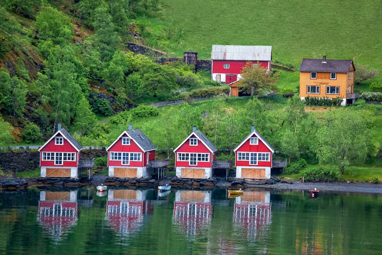
Fjord Life where the land meets the sea
Most of the farms in the Aurlandsdalen Valley were abandoned between 1875 and 1907, many emigrated to America to become farmers. Some have been restored for tourism. The Sognefjord runs through many municipalities: Solund, Gulen, Hyllestad, Høyanger, Vik, Sogndal, Lærdal, Aurland, Årdal, and ending in Luster (at the small village of Skjolden).
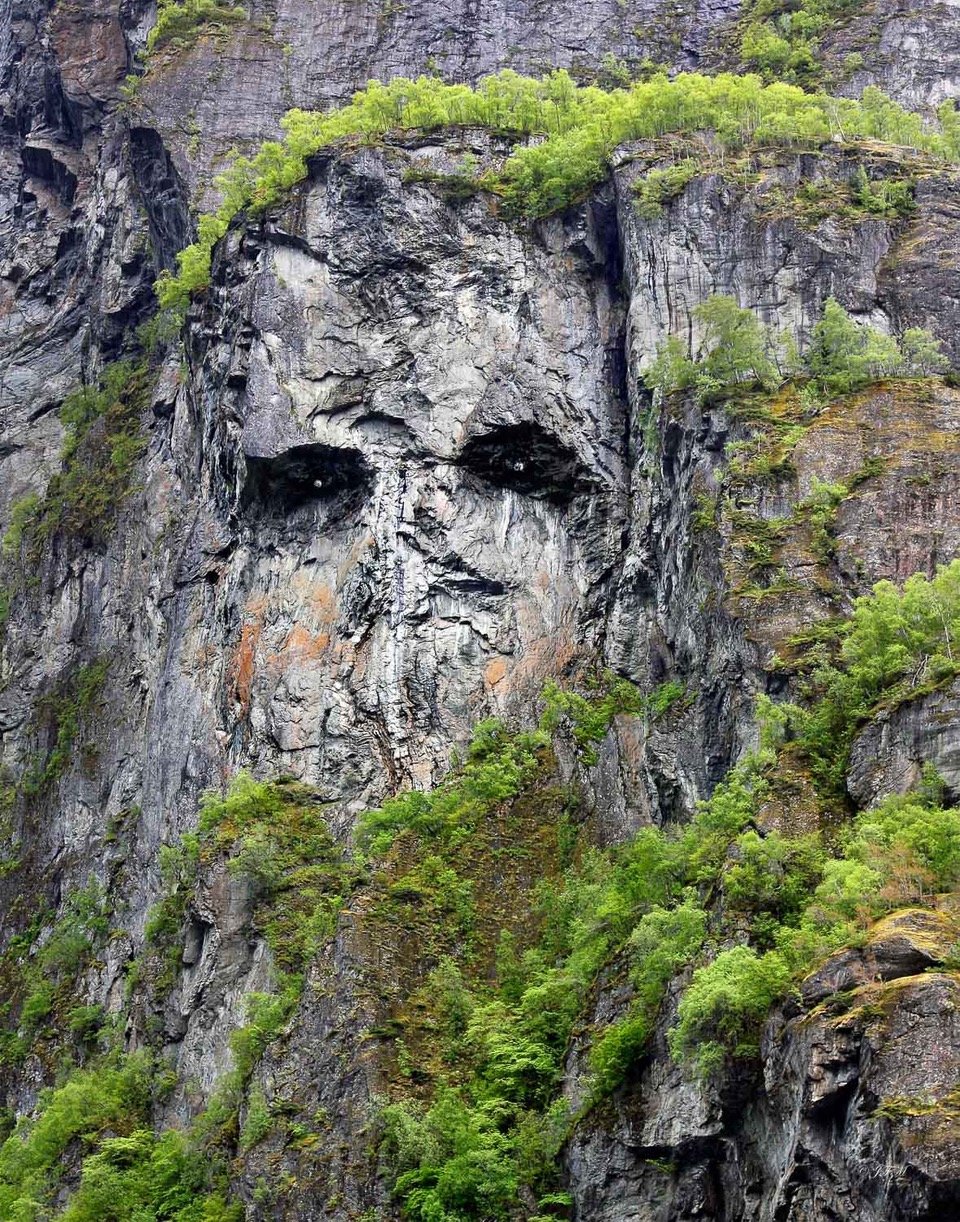
Troll Face Cliff Geiranger fjord
A troll (originated from Old Norse troll,. In Old Norse sources, beings described as trolls dwell in isolated rocks, mountains, or caves, live together in small family units, and are rarely helpful to human beings. Trolls are sometimes associated with particular landmarks, which at times may be explained as formed from a troll exposed to sunlight. This is located in the Geiranger fjord, Stranda Municipality, Norway.

Ålesund, Norway "The Most Beautiful Town In Norway"
Ålesund, Norway is in the Sunnmøre district. It is known for its salmon fishing that is reflected in its town coat of arms and furniture making. The statue of this fisherman, in the city of Ålesund was erected in memory of all the fishermen who have lost their lives at sea. Ålesund has been awarded the title of "The most beautiful town in Norway" by the Norwegian people. The unique Art nouveu style or Jugendstyle architecture makes Ålesund different from any other Norwegian city. In 1904, fire totally destroyed about 850 buildings in the city center. The German King, Kaiser Wilhelm II, was a frequent visitor to this area and got a substantial amount of aid sent to rebuild the city.

Trondheimsfjord
Trondheimsfjorden, pronounced [ˈtrɔnhæjmsˈfjuːrən]), an inlet of the Norwegian Sea, is Norway's third longest fjord at 130 kilometres (81 mi) long. It is located in the west central part of the country, and it stretches from Ørland in west to Steinkjer in north, passing the city of Trondheim on its way. Its maximum depth is 617 metres (2,024 ft), just inside of Agdenes. It was an important waterway in the Viking Age, as it is still today. Four giant squids have been found in the fjord, which is among the highest concentrations in the world.[2]. Åsenfjord, inner reaches of Trondheimsfjord near Stjørdal is where the largest German Battleship - Tirpitz -was moored during parts of WW2.

Barents Sea
View of the coast line in the Barents Sea on the way to Honningsvåg -the northernmost city of Norway. It is situated at a bay on the southeastern side of the large island of Magerøya, while the famous North Cape and its visitors center is on the northern side of the island. The ice-free ocean (southwestern part of the Barents Sea) provides rich fisheries and tourism. Even though Honningsvåg is located at the northernmost extreme of Europe, it has a subarctic climate, due to the Gulf Stream. Also, there is no permafrost because the mean annual temperature is 2 °C (36 °F).

Geirangerfjord -Flydal Viewpoint
Looking to the North at Eagle Road's 11 hairpin switch backs. Geirangerfjorden is a fjord in the Sunnmøre region of Møre og Romsdal county, Norway. The small village of Geiranger is located at the end of the fjord where the Geirangelva river empties into it. The fjord is one of Norway's most visited tourist sites. In 2005, it was listed as a UNESCO World Heritage Site, jointly with the Nærøyfjorden. Along the fjord's sides there lie a number of now-abandoned farms. Some restoration has been made by the Storfjordens venner association.

Djupvasshytta Hotel
The Dalsnibba mountain peak is east of here at1038 moh. altitude. This is the Dalsnibba Pass from Fylkesvei between Geiranger and Lom and the Djupvasshytta Hotel at 1030 moh. Lake Djupvatnet is covered with ice and snow behind the building/to the right. In warmer weather it would be shimmering blue-green.

Dalsnibba Pass
June 3, 2015 the Dalsnibba Pass still has 12 to 15 foot snow drifts. The Dalsnibba mountain peak is east of here at1038 moh. altitude. This is the Dalsnibba Pass from Fylkesvei between Geiranger and Lom and the Djupvasshytta Hotel at 1030 moh. Lake Djupvatnet is covered with ice and snow behind the building/to the right. In warmer weather it would be shimmering blue-green.

Fantoft Stave Church
Fantoft Stave Church (Norwegian: Fantoft stavkirke) is a reconstructed stave church in the Fana borough of the city of Bergen, Norway. The church was originally built in Fortun in Sogn, a village near inner or eastern end of Sognefjord around the year 1150. In the 19th century the church was threatened by demolition, as were hundreds of other stave churches in Norway. The church was bought by consul Fredrik Georg Gade and saved by moving it in pieces to Fantoft near (now in) Bergen in 1883. Outside the church stands a stone cross from Tjora in Sola.
On 6 June 1992, the church was destroyed by arson; the first in a string of church burnings by members of the early Norwegian black metal scene

Skulstad Fisk
Buildings at Bryggen or Wharf World Heritage Site Bergen, Norway include: Bellgården (a 300 year old building),[4] Svensgården, Enhjørningsgården, Bredsgården, Bugården,[5] Engelgården

Nordkapp Scandes Mountain Range Coastline
A Three panel Panorama of the Scandinavian Mountain range. The Scandes is a mountain range that runs through the Scandinavian Peninsula. The Scandinavian Mountains are equivalent to the Scandinavian Caledonides. The western sides of the mountains drop precipitously into the North Sea and Norwegian Sea, forming the famous fjords of Norway, whereas to the northeast they gradually curve towards Finland.
The Norwegian Sea (Norskehavet) is a marginal sea in the North Atlantic Ocean, northwest of Norway. It is located between the North Sea (i.e. north of the United Kingdom) and the Greenland Sea and adjoins the North Atlantic Ocean to the west and the Barents Sea to the northeast. The warm North Atlantic Current ensures relatively stable and high water temperatures, so that unlike the Arctic seas, the Norwegian Sea is ice-free throughout the year. Recent research has concluded that the large volume of water in the Norwegian Sea with its large heat absorption capacity is more important as a source of Norway's mild winters than the Gulf Stream and its extensions.

Bryggen Handel #1
Buildings at Bryggen or Wharf World Heritage Site Bergen, Norway include: Bellgården (a 300 year old building),[4] Svensgården, Enhjørningsgården, Bredsgården, Bugården,[5] Engelgården

Bryggen Handel #2
Buildings at Bryggen or Wharf World Heritage Site Bergen, Norway include: Bellgården (a 300 year old building),[4] Svensgården, Enhjørningsgården, Bredsgården, Bugården,[5] Engelgården

Honningsvag, Norway Coastline
Honningsvag, Norway or North Point is the furthest point of land extending into the Artic Circle where the sun never sets in the summer and does not rise in the winter.

Mustard BoatHouse
Honningsvag, Norway or North Point is the furthest point of land extending into the Artic Circle where the sun never sets in the summer and does not rise in the winter.

Torrfiskstativ #1
The "Torrfiskstativ " is the traditional cod drying A shaped rack that is not being used today. It takes the sun & air three months to dry the cod fllets that were traded in the past. Today the heads are also dried to be ground up into food for the fish farms. This one is located in the Artic Circle at Honningsvag, Norway.

Torrfiskstativ #2
The "Torrfiskstativ " is the traditional cod drying A shaped rack that is not being used today. It takes the sun & air three months to dry the cod fllets that were traded in the past. Today the heads are also dried to be ground up into food for the fish farms. This one is located in the Artic Circle at Honningsvag, Norway.

Midnight Sun
This photo was taken at 3:30 AM in the Artic Circle near Molde, Norway.

Oystercatcher
Oystercatcher - Haematopus ostralegus - feeds on tidal flats & other open ground. Theis one was at the Haholmen Archipelago at the Fraenfjord near Molde, Norway that was the starting point for the Viking voyages across the Altantic. Captian Ragnar Thrseth built the replica Viking ship, Saga Siglar, and repeated these trips across the Altantic and around the world to prove it was done.

Haholmen Archipelago Green Row Boat
The Haholmen Archipelago at the Fraenfjord near Molde, Norway was the starting point for the Viking voyages across the Altantic. Captian Ragnar Thrseth built the replica Viking ship, Saga Siglar, and repeated these trips across the Altantic and around the world to prove it was done.

Hirt Skum
Hirt Skum is the Norwiegian name of this small white flower. This was found at Geitoya or "Goat Island" on the Atlantic Ocean Road in the Haholmen Archipelago, consisting of around 20 small islands and ilets near Molde, Norway.
Norway